Physiographic regions[edit]
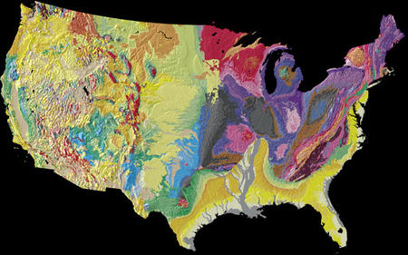
The geography of the United States varies across their immense area. Within the continental U.S., eight distinct physiographic divisions exist, though each is composed of several smaller physiographic subdivisions.[9]These major divisions are:
- Laurentian Upland - part of the Canadian Shield that extends into the northern United States Great Lakes area.
- Atlantic Plain - the coastal regions of the eastern and southern parts includes the continental shelf, the Atlantic Coast and the Gulf Coast.
- Appalachian Highlands - lying on the eastern side of the United States, it includes the Appalachian Mountains, the Watchung Mountains, the Adirondacks and New England province originally containing the Great Eastern Forest.
- Interior Plains - part of the interior contentintal United States, it includes much of what is called the Great Plains.
- Interior Highlands - also part of the interior contentintal United States, this division includes the Ozark Plateau.
- Rocky Mountain System - one branch of the Cordilleran system lying far inland in the western states.
- Intermontane Plateaus - also divided into the Columbia Plateau, the Colorado Plateau and the Basin and Range Province, it is a system of plateaus, basins, ranges and gorges between the Rocky and Pacific Mountain Systems. It is the setting for the Grand Canyon, the Great Basin and Death Valley.
- Pacific Mountain System - the coastal mountain ranges and features in the west coast of the United States.
The Atlantic coast of the United States is low, with minor exceptions. The Appalachian Highland owes its oblique northeast-southwest trend to crustal deformations which in very early geological time gave a beginning to what later came to be the Appalachian mountain system. This system had its climax of deformation so long ago (probably in Permian time) that it has since then been very generally reduced to moderate or low relief. It owes its present-day altitude either to renewed elevations along the earlier lines or to the survival of the most resistant rocks as residual mountains. The oblique trend of this coast would be even more pronounced but for a comparatively modern crustal movement, causing a depression in the northeast resulting in an encroachment of the sea upon the land. Additionally, the southeastern section has undergone an elevation resulting in the advance of the land upon the sea.
While the Atlantic coast is relatively low, the Pacific coast is, with few exceptions, hilly or mountainous. This coast has been defined chiefly by geologically recent crustal deformations, and hence still preserves a greater relief than that of the Atlantic. The low Atlantic coast and the hilly or mountainous Pacific coast foreshadow the leading features in the distribution of mountains within the United States.
The east coast Appalachian system, originally forest covered, is relatively low and narrow and is bordered on the southeast and south by an important coastal plain. The Cordilleran system on the western side of the continent is lofty, broad and complicated having two branches, the Rocky Mountain System and the Pacific Mountain System. In between these mountain systems lie the Intermontaine Plateaus. Both the Columbia River and Colorado River rise far inland near the easternmost members of the Cordilleran system, and flow through plateaus and intermontaine basins to the ocean. Heavy forests cover the northwest coast, but elsewhere trees are found only on the higher ranges below the Alpine region. The intermontane valleys, plateaus and basins range from treeless to desert with the most arid region being in the southwest.
The Laurentian Highlands, the Interior Plains and the Interior Highlands lie between the two coasts, stretching from the Gulf of Mexico northward, far beyond the national boundary, to the Arctic Ocean. The central plains are divided by a hardly perceptible height of land into a Canadian and a United States portion. It is from the United States side, that the great Mississippi system discharges southward to the Gulf of Mexico. The upper Mississippi and some of the Ohio basin is the semi-arid prairie region, with trees originally only along the watercourses. The uplands towards the Appalachians were included in the great eastern forested area, while the western part of the plains has so dry a climate that its native plant life is scanty, and in the south it is practically barren.
Elevation extremes:
- Lowest point: Death Valley, Inyo County, California −280 ft (−85.3 m)
- Highest point: Denali, Denali Borough, Alaska 20,310 ft (6,190.5 m)


No comments:
Post a Comment