Physiographic regions[edit]
India can be divided into six physiographic regions. They are
- The Northern Mountains
- The Peninsular Plateaus
- Indo Gangetic Plains
- Thar Desert
- The Coastal Plains
- The Islands
The Northern Mountains[edit]
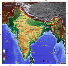
A great arc of mountains, consisting of the Himalayas of Nepal, Hindu Kush, and Patkai ranges define the northern Indian subcontinent. These were formed by the ongoing tectonic collision of the Indian and Eurasian plates. The mountains in these ranges include some of the world's tallest mountains which act as a natural barrier to cold polar winds. They also facilitate the monsoon winds which in turn influence the climate in India. Rivers originating in these mountains flow through the fertile Indo–Gangetic plains. These mountains are recognised by biogeographers as the boundary between two of the Earth's great ecozones: the temperate Palearctic that covers most of Eurasia and the tropical and subtropical Indomalaya ecozone which includes the Indian subcontinent, Southeast Asia and Indonesia.
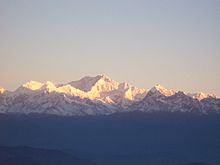
The Himalayan range is the world's highest mountain range, with its tallest peak Mt. Everest (8,848 metres (29,029 ft)) on the Nepal–China border.[17] They form India's northeastern border, separating it from northeastern Asia. They are one of the world's youngest mountain ranges and extend almost uninterrupted for 2,500 km (1,600 mi), covering an area of 500,000 km2 (190,000 sq mi).[17] The Himalayas extend from Jammu and Kashmir in the north to Arunachal Pradesh in the east. These states along with Himachal Pradesh, Uttarakhand, and Sikkim lie mostly in the Himalayan region. Numerous Himalayan peaks rise over 7,000 m (23,000 ft) and the snow line ranges between 6,000 m (20,000 ft) in Sikkim to around 3,000 m (9,800 ft) in Kashmir. Kanchenjunga—on the Sikkim–Nepal border—is the highest point in the area administered by India. Most peaks in the Himalayas remain snowbound throughout the year. The Himalayas act as a barrier to the frigid katabatic winds flowing down from Central Asia. Thus, North India is kept warm or only mildly cooled during winter; in summer, the same phenomenon makes India relatively hot.
- The Karakoram is situated in the disputed state of Jammu and Kashmir. It has more than sixty peaks above 7,000 m (23,000 ft), including K2, the second highest peak in the world 8,611 m (28,251 ft). K2 is just 237 m (778 ft) smaller than the 8,848 m (29,029 ft) Mount Everest. The range is about 500 km (310 mi) in length and the most heavily glaciated part of the world outside of the polar regions. The Siachen Glacier at 76 km (47 mi) and the Biafo Glacier at 67 km (42 mi) rank as the world's second and third-longest glaciers outside the polar regions.[18] Just to the west of the northwest end of the Karakoram, lies the Hindu Raj range, beyond which is the Hindu Kush range. The southern boundary of the Karakoram is formed by the Gilgit, Indus and Shyok rivers, which separate the range from the northwestern end of the Himalayas.
- The Patkai, or Purvanchal, are situated near India's eastern border with Burma. They were created by the same tectonic processes which led to the formation of the Himalayas. The physical features of the Patkai mountains are conical peaks, steep slopes and deep valleys. The Patkai ranges are not as rugged or tall as the Himalayas. There are three hill ranges that come under the Patkai: the Patkai–Bum, the Garo–Khasi–Jaintia and the Lushai hills. The Garo–Khasi range lies in Meghalaya. Mawsynram, a village near Cherrapunji lying on the windward side of these hills, has the distinction of being the wettest place in the world, receiving the highest annual rainfall.


No comments:
Post a Comment