Geological development[edit]
Main article: Geology of India
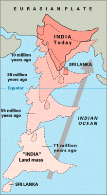
India is situated entirely on the Indian Plate, a major tectonic plate that was formed when it split off from the ancient continent Gondwanaland (ancient landmass, consisting of the southern part of the supercontinent of Pangea). The Indo-Australian plate is subdivided into the Indian and Australian plates. About 90 million years ago, during the late Cretaceous Period, the Indian Plate began moving north at about 15 cm/year (6 in/yr).[6] About 50 to 55 million years ago, in the Eocene Epoch of the Cenozoic Era, the plate collided with Asia after covering a distance of 2,000 to 3,000 km (1,243 to 1,864 mi), having moved faster than any other known plate. In 2007, German geologists determined that the Indian Plate was able to move so quickly because it is only half as thick as the other plates which formerly constituted Gondwanaland.[7] The collision with the Eurasian Plate along the modern border between India and Nepal formed the orogenic belt that created the Tibetan Plateau and the Himalayas. As of 2009, the Indian Plate is moving northeast at 5 cm/yr (2 in/yr), while the Eurasian Plate is moving north at only 2 cm/yr (0.8 in/yr). India is thus referred to as the "fastest continent".[7] This is causing the Eurasian Plate to deform, and the Indian Plate to compress at a rate of 4 cm/yr (1.6 in/yr).
Political geography[edit]
Main article: States and territories of India
India is divided into 29 states (further subdivided into districts) and 7 union territories.
India's borders run a total length of 15,106.70 km (9,386.87 mi).[1] Its borders with Pakistan and Bangladesh were delineated according to the Radcliffe Line, which was created in 1947 during Partition of India. Its western border with Pakistan extends up to 3,323 km (2,065 mi), dividing the Punjab region and running along the boundaries of the Thar Desert and the Rann of Kutch.[1] This border runs along the Indian states of Jammu & Kashmir, Rajasthan, Gujarat, and Punjab.[8] Both nations delineated a Line of Control (LoC) to serve as the informal boundary between the Indian and Pakistan-administered areas of Kashmir. According to India's claim, it also shares a 106 km (66 mi) border with Afghanistan in northwestern Kashmir, which is under Pakistani control.[1]
India's border with Bangladesh runs 4,096.70 km (2,545.57 mi).[1] West Bengal, Assam, Meghalaya, Tripura and Mizoram are the States which share the border with Bangladesh.[9] Before 2015, there were 92 enclaves of Bangladesh on Indian soil and 106 enclaves of India were on Bangladeshi soil.[10] These enclaves were eventually exchanged in order to simplify the border.[11] After the exchange, India lost roughly 40 km² (10,000 acres) to Bangladesh.[12]
The Line of Actual Control (LAC) is the effective border between India and the People's Republic of China. It traverses 4,057 km along the Indian states of Jammu and Kashmir, Uttarakhand, Himachal Pradesh, Sikkim and Arunachal Pradesh.[13] The border with Burma (Myanmar) extends up to 1,643 km (1,021 mi) along the southern borders of India's northeastern states viz. Arunachal Pradesh, Nagaland, Manipur and Mizoram.[14] Located amidst the Himalayan range, India's border with Bhutan runs 699 km (434 mi).[1] Sikkim, West Bengal, Assam and Arunachal Pradesh are the States, which share the border with Bhutan.[15] The border with Nepal runs 1,751 km (1,088 mi) along the foothills of the Himalayas in northern India.[1] Uttarakhand, Uttar Pradesh, Bihar, West Bengal and Sikkim are the States, which share the border with Nepal.[16] The Siliguri Corridor, narrowed sharply by the borders of Bhutan, Nepal and Bangladesh, connects peninsular India with the northeastern states.


No comments:
Post a Comment