Indo-Gangetic plain[edit]
Main article: Indo-Gangetic plain
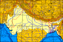
The Indo-Gangetic plains, also known as the Great Plains are large alluvial plains dominated by three main rivers, the Indus, Ganges, and Brahmaputra. They run parallel to the Himalayas, from Jammu and Kashmir in the west to Assam in the east, and drain most of northern and eastern India. The plains encompass an area of 700,000 km2 (270,000 sq mi). The major rivers in this region are the Ganges, Indus, and Brahmaputra along with their main tributaries–Yamuna, Chambal, Gomti, Ghaghara, Kosi, Sutlej, Ravi, Beas, Chenab, and Tista—as well as the rivers of the Ganges Delta, such as the Meghna.
The great plains are sometimes classified into four divisions:
- The Bhabar belt is adjacent to the foothills of the Himalayas and consists of boulders and pebbles which have been carried down by streams. As the porosity of this belt is very high, the streams flow underground. The Bhabar is generally narrow with its width varying between 6 to 15 km (3.7 to 9.3 mi).
- The Tarai belt lies south of the adjacent Bhabar region and is composed of newer alluvium. The underground streams reappear in this region. The region is excessively moist and thickly forested. It also receives heavy rainfall throughout the year and is populated with a variety of wildlife.
- The Bangar belt consists of older alluvium and forms the alluvial terrace of the flood plains. In the Gangetic plains, it has a low upland covered by laterite deposits.
- The Khadar belt lies in lowland areas after the Bangar belt. It is made up of fresh newer alluvium which is deposited by the rivers flowing down the plain.
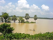
The Indo-Gangetic belt is the world's most extensive expanse of uninterrupted alluvium formed by the deposition of silt by the numerous rivers. The plains are flat making it conducive for irrigation through canals. The area is also rich in ground water sources.The plains are one of the world's most intensely farmed areas. The main crops grown are rice and wheat, which are grown in rotation. Other important crops grown in the region include maize, sugarcane and cotton. The Indo-Gangetic plains rank among the world's most densely populated areas.[citation needed]
Thar Desert[edit]
Main article: Thar Desert
The Thar Desert (also known as the deserts) is by some calculations the world's seventh largest desert, by some others the tenth.[29] It forms a significant portion of western India and covers an area of 200,000 to 238,700 km2 (77,200 to 92,200 sq mi).[30] The desert continues into Pakistan as the Cholistan Desert. Most of the Thar Desert is situated in Rajasthan, covering 61% of its geographic area.
About 10 percent of this region comprises sand dunes, and the remaining 90 percent consist of craggy rock forms, compacted salt-lake bottoms, and interdunal and fixed dune areas. Annual temperatures can range from 0 °C (32 °F) in the winter to over 50 °C (122 °F) during the summer. Most of the rainfall received in this region is associated with the short July–September southwest monsoon that brings 100 to 500 mm (3.9 to 19.7 in) of precipitation. Water is scarce and occurs at great depths, ranging from 30 to 120 metres (98 to 394 ft) below the ground level.[31] Rainfall is precarious and erratic, ranging from below 120 mm (4.7 in) in the extreme west to 375 mm (14.8 in) eastward.The only river in this region is Luni. The soils of the arid region are generally sandy to sandy-loam in texture. The consistency and depth vary as per the topographical features. The low-lying loams are heavier may have a hard pan of clay, calcium carbonate or gypsum.
In western India, the Kutch region in Gujarat and Koyna in Maharashtra are classified as a Zone IV region (high risk) for earthquakes. The Kutch city of Bhuj was the epicentre of the 2001 Gujarat earthquake, which claimed the lives of more than 1,337 people and injured 166,836 while destroying or damaging near a million homes.[32] The 1993 Latur earthquake in Maharashtra killed 7,928 people and injured 30,000.[33] Other areas have a moderate to low risk of an earthquake occurring.[34]


No comments:
Post a Comment