Climate[edit]
Main articles: Climate of India and Climatic regions of India
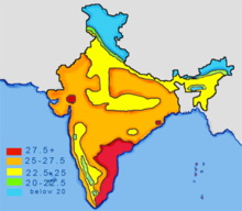
Based on the Köppen system, India hosts six major climatic subtypes, ranging from arid desert in the west, alpine tundra and glaciers in the north, and humid tropical regions supporting rainforests in the southwest and the island territories. The nation has four seasons: winter (January–February), summer (March–May), a monsoon (rainy) season (June–September) and a post-monsoon period (October–December)'.[39]
The Himalayas act as a barrier to the frigid katabatic winds flowing down from Central Asia.' Thus, North India is kept warm or only mildly cooled during winter; in summer, the same phenomenon makes India relatively hot. Although the Tropic of Cancer—the boundary between the tropics and subtropics—passes through the middle of India, the whole country is considered to be tropical.[citation needed]
Summer lasts between March and June in most parts of India. Temperatures can exceed 40 °C (104 °F) during the day. The coastal regions exceed 30 °C (86 °F) coupled with high levels of humidity. In the Thar desert area temperatures can exceed 45 °C (113 °F). The rain-bearing monsoon clouds are attracted to the low-pressure system created by the Thar Desert. The southwest monsoon splits into two arms, the Bay of Bengal arm and the Arabian Sea arm. The Bay of Bengal arm moves northwards crossing northeast India in early June. The Arabian Sea arm moves northwards and deposits much of its rain on the windward side of Western Ghats. Winters in peninsula India see mild to warm days and cool nights. Further north the temperature is cooler. Temperatures in some parts of the Indian plains sometimes fall below freezing. Most of northern India is plagued by fog during this season. The highest temperature recorded in India was 51 °C (124 °F) in Phalodi, Rajasthan. The lowest was −45 °C (−49 °F) in Kashmir.
Climate[edit]
Main article: Geology of India
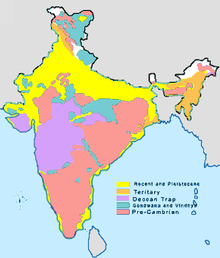
India's geological features are classified based on their era of formation.[47] The Precambrian formations of Cudappah and Vindhyan systems are spread out over the eastern and southern states. A small part of this period is spread over western and central India.[47] The Paleozoic formations from the Cambrian, Ordovician, Silurian and Devonian system are found in the Western Himalaya region in Kashmir and Himachal Pradesh.[47] The Mesozoic Deccan Traps formation is seen over most of the northern Deccan; they are believed to be the result of sub-aerial volcanic activity.[47] The Trap soil is black in colour and conducive to agriculture. The Carboniferous system, Permian System and Triassic systems are seen in the western Himalayas. The Jurassic system is seen in the western Himalayas and Rajasthan.
Tertiary imprints are seen in parts of Manipur, Nagaland, Arunachal Pradesh and along the Himalayan belt. The Cretaceous system is seen in central India in the Vindhyas and part of the Indo-Gangetic plains.[47] The Gondowana system is seen in the Narmada River area in the Vindhyas and Satpuras. The Eocene system is seen in the western Himalayas and Assam. Oligocene formations are seen in Kutch and Assam.[47] The Pleistocene system is found over central India. The Andaman and Nicobar Island are thought to have been formed in this era by volcanoes.[47]The Himalayas were formed by the convergence and deformation of the Indo-Australian and Eurasian Plates. Their continued convergence raises the height of the Himalayas by 1 cm each year.
Soils in India can be classified into 8 categories: alluvial, black, red, laterite, forest, arid & desert, saline & alkaline and peaty & organic soils.[48][49] Alluvial soil constitute the largest soil group in India, constituting 80% of the total land surface.[49] It is derived from the deposition of silt carried by rivers and are found in the Great Northern plains from Punjab to the Assam valley.[49] Alluvial soil are generally fertile but they lack nitrogen and tend to be phosphoric.[49] National Disaster Management Authority says that 60% of Indian landmass is prone to earthquake and 8% susceptible to cyclone risks.
Black soil are well developed in the Deccan lava region of Maharashtra, Gujarat, and Madhya Pradesh.[50] These contain high percentage of clay and are moisture retentive.[49] Red soil are found in Tamil Nadu, Karnataka plateau, Andhra plateau, Chota Nagpur plateau and the Aravallis.[50] These are deficient in nitrogen, phosphorus and humus.[49][50] Laterite soils are formed in tropical regions with heavy rainfall. Heavy rainfall results in leaching out all soluble material of top layer of soil. These are generally found in Western ghats, Eastern ghats and hilly areas of northeastern states that receive heavy rainfall. Forest soils occur on the slopes of mountains and hills in Himalayas, Western Ghats and Eastern Ghats. These generally consist of large amounts of dead leaves and other organic matter called humus.


No comments:
Post a Comment